 |
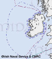
The Exclusive Fishery Limit extends
200 nautical miles to the west of Ireland. |
Ireland’s rich marine heritage is not restricted to the nearshore
zone. Ireland’s offshore zone (arbitrarily defined as either waters
beyond the 12 nautical mile territorial sea limit or waters greater than
50m in depth) includes the 200 nautical mile Exclusive Fishery Limits
(EFL) and beyond to the edge of the continental shelf, reaching water
depths of up to 4,500m (see map). It has a rich cultural
and natural heritage resource.
For the purpose of this directory, Cultural Heritage in the offshore zone, as defined in the previous paragraph, will be referred to as Underwater Archaeology. Intangible heritage such as folklore, folklife and language will be addressed in the folklore / folklife section of the directory. Underwater Archaeology in the offshore zone is comprised predominantly of shipwrecks and artefacts associated with shipwrecks. However, the incidence of shipwreck is more frequently associated with the coastal zone, a fact reflected by the higher record of occurrence as a result of vessels having been blown ashore by inclement weather, or having struck submerged rocks or hazards in inshore areas. The Underwater Archaeological Unit of the DoEHLG is currently completing the Maritime Sites and Monuments Record (MSMR), consisting of a database of all marine archaeological sites around the coast (including shipwrecks). The work includes a review of data on historical wrecks contained in Lloyd’s List. The database will classify wrecks into zones around the coast. The greatest proportion of wrecks occurs off the east and southeast coast and the majority date from the period 1850-99. Wrecks over 100 years old are afforded State protection via the National Monuments Acts.
Fish
 |
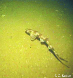
| Scyliorhinos
species on sand sediment habitat extracted from a towed remotely
operated vehicle (ROV) video footage |
Deepwater fisheries, mainly conducted in water depths greater than about 400 m, target species such as Orange roughy (Hoplostethus atlanticus), Black scabbardfish (Aphanopus carbo), Roundnose grenadier (Coryphaenoides rupestris), Ling (Molva molva), Portuguese dogfish (Centroscymnus coelolepis) and Leafscale gulper shark (Centrophorus squamosus). Click here, for the Marine Institute fisheries advice on deepwater species and a list of commercially exploited deep-water fish species, including sharks. Click here for information on fisheries stock assessment and past and current Marine Fisheries Research and Development projects involving Irish partners. Aside from commercially important species of fish in deep waters, little is known about deepwater fish habitats or species assemblages. This is changing, however. For example, the Irish National Seabed Survey is providing information that will assist in understanding the physical aspects deepwater fish habitats. A list of 375 fish species recorded in Irish waters (including offshore), along with species information, can be accessed through FishBase. The Irish Naturalists’ Journal publishes records of rare/unusual fish taken in both inshore and offshore waters.
OFFSHORE SEABED AND HABITAT MAPPING PROGRAMMES
The Irish National Seabed Survey
(INSS), is a seven-year survey (2000-2006) of Ireland's seabed and is
managed by the Geological
Survey of Ireland (GSI) in co-operation with the Marine
Institute and other strategic partners (read more about INSS).
The INSS aims to survey Ireland's territorial seabed; an area that is
approximately ten times the size of Ireland's land area. It reaches more
than 600 miles out into the Atlantic Ocean to waters of more than 4,500
metres in depth. The INSS is primarily a multibeam sonar survey (read
more)
aimed at providing detailed bathymetry (water depth) data and knowledge
of the nature of the seabed and its overlying sediment. Magnetic and gravity
techniques are helping to evaluate the nature and structure of the deeper
geology.
An important part of the seabed survey is the building up of marine expertise. To this end, the Marine Institute manages an Ancillary Project Programme. Heritage-related ancillary projects include seabird and cetacean surveys and seabed habitat/biodiversity studies. For example, cetacean recorders accompany various vessels carrying out the survey work. In addition, crews on survey vessels report sightings of cetaceans to the Irish Whale and Dolphin Group as part of their sightings scheme. A group of researchers based at the Department of Earth & Ocean Sciences (NUI Galway) are building on the baseline bathymetric mapping and geophysical data acquired under the Irish National Seabed Survey to produce benthic habitat maps for areas of the seabed in the offshore region. The project involves the acquisition and analysis of high resolution seafloor video and acoustic data in areas of interest on the Irish continental margin using Remotely Operated Vehicles (ROVs).
MESH (Development of a framework for Mapping European Seabed Habitats) is an international marine habitat mapping programme supported by the EU INTERREG IIIB fund and involving 12 partners across the UK, Ireland, the Netherlands, Belgium and France. MESH aims to produce seabed habitat maps for north-west Europe and develop international standards and protocols for seabed mapping studies. The Marine Institute are the Irish MESH partner. For further information click here.
IMAGIN
The Irish Sea Marine Aggregates Initiative (IMAGIN) started officially
on Feb 3rd 2005, and is a 2-year project funded under the Ireland/Wales
INTERREG IIIA Community Initiative Programme 2000-2006. The overall aim
of IMAGIN is to facilitate the evolution of a strategic framework within
which exploitation of marine aggregate resources from the Irish Sea could
be sustainably managed with minimum risk of impact on marine and coastal
environments, ecosystems and other marine users. An important aspect of
this project is seabed mapping to provide essential baseline data on the
availability of marine aggregates, environmental conditions and sensitivity
of ecosystems in the Irish Sea. Partners in this project are the Coastal
and Marine Resources Centre (CMRC) in UCC, Geoscience
Wales, the Marine
Institute, the Geological
Survey of Ireland (GSI) and the Lead
Partnership. For further information on the IMAGIN project visit the
IMAGIN website here.
The South-West Irish Sea Survey (SWISS) project mapped the bio-sedimentary communities of the western side of the southern part of the Irish Sea. The methodology of the project was chosen so as to be complementary to the Welsh BIOMÔR project, which had obtained comparable data for the eastern side of the south Irish Sea.
HABMAP (HABitat MAPping for conservation and management of the Southern
Irish Sea) is a three-year project which aims to synthesise existing information
in order to produce working habitat maps of the seabed of the southern
Irish Sea (read more).
Relationships between the physical data and the biological data will be
analysed to develop a model to interpolate biological data to produce
biotope maps. The project builds on previous work in the south-west Irish
Sea, such as the SWISS and BIOMAR.
The data from these projects will be utilised and combined with physical
data to produce habitat maps. The project will also link in with the NW
Europe benthic mapping project (MESH).More information
on the Irish HabMap partners can be found at the following link.
COLD-WATER CORALS
 |
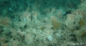
| Live deep-water
corals. Fig. 4A from Wheeler, A., Kozachenko, M., Beyer, A., Huvenne,
V.A.I., Masson, D. & Olu-Le Roy K. (2005). Sedimentary Processes
and Carbonate Mound Morphology: The Belgica Mounds, Porcupine Seabight,
NE Atlantic. In: A. Freiwald & J.M. Roberts (eds). Proceedings
of the 2nd Internation Symposium on Deep-water Corals, Springer-Verlag. |
In the deep waters off Ireland’s west coast lie extensive areas
of cold-water coral reefs. These reefs are formed by a number of coral
species (for more information see here).
Lophelia pertusa is the most common cold-water coral species.
The corals grow a branching skeleton of calcium carbonate to form a colony
and very slowly, over millennia, reefs and mounds are formed. Carbonate
mounds are underwater mounds that are believed to be the result of fossil
coral and sediment build-ups. These mounds can reach heights of up to
300m and stretch over several kilometres in length. They often support
live coral colonies on their summits as they continue to grow. On average
the coral structure grows at the rate of just a few millimetres in height
per year. The intact coral structures are estimated to be up to 8,500
years old and the larger mounds could be up to 2.5 million years old.
Up to sixty percent of the Lophelia pertusa reefs in the northeast
Atlantic is thought to occur in Irish waters at depths of 500-1500m. They
tend to be found in areas where there are strong currents. These currents
supply food for the corals and remove sediment, which could smother the
coral polyps. Lophelia pertusa can also occur as single colonies
or on isolated boulders, rocky outcrops and rough seabed. View
a map showing where cold-water corals have been found.
The habitats provided by both living coral and the dead skeletons create
biodiversity hot spots on the edge of the continental shelf. Lophelia
reefs act as an important settlement area and refuge for a host of animal
species, from small invertebrates (starfish, sea urchins, feather-stars
and brittle-stars, sponges, worms and molluscs) to commercially important
fish species. These species thrive in the fast-flowing, food-rich deep-water
currents. The diversity of some groups of animals associated with these
deep-water coral banks can approach that found in the tropics. Up to 800
animal species have been recorded on cold-water coral reefs, some of which
are rare or previously unknown in these water masses.
Legal Protection for Coral Reefs
Under the EU Habitats Directive, the Annex I habitat ‘reefs’ includes biogenic concretions – where the reef structure is created by the animals themselves (click here for further definition). Reefs formed by corals fall into this category and require protection through the designation of Special Areas of Conservation (SACs). In 2002, the UK announced a proposal to designate the Darwin Mounds as a Special Area of Conservation, under the EU Habitats Directive. Read more. To date, none of the Special Areas of Conservation designated by Ireland under the Habitats Directive extend beyond Ireland's territorial waters (12 nautical mile limit). The National Parks and Wildlife Service of the Department of Environment, Heritage and Local Government is currently in the process of selecting cold-water coral sites that are of conservation importance for designation as SACs. Annex V (On the Protection and Conservation of the Ecosystems and Biological Diversity of the Maritime Area) of the OSPAR Convention offers another mechanism to protect Lophelia reefs. Under Annex V contracting parties may vote for measures such as Marine Protected Areas to protect habitats or species that are considered to be in need of protection. Carbonate mounds and Lophelia pertusa reefs are currently included in the OSPAR list of threatened and/or declining species and habitats (click here for full list).
The discovery of coral reefs in the North-east Atlantic has prompted major European research projects with strong Irish involvement aimed at understanding the geology, morphology and biology of carbonate mounds and associated coral areas. |
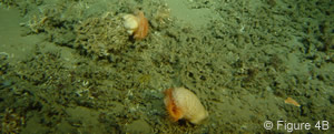
Dead sediment-clogged deep water
corals. Fig. 4B from Wheeler, A., Kozachenko, M., Beyer, A., Huvenne,
V.A.I., Masson, D.& Olu-Le Roy K. (2005). Sedimentary Processes
and Carbonate Mound Morphology: The Belgica Mounds, Porcupine Seabight,
NE Atlantic. In: A. Freiwald & J.M. Roberts (eds). Proceedings
of the 2nd Internation Symposium on Deep-water Corals, Springer-Verlag. |
ECOMOUND - The major objective of this proposal was to define the environmental controls and processes involved in the development and distribution of carbonate mounds on the NW European continental margin. Irish partners are the Martin Ryan Institute (NUI, Galway) and the Coastal and Marine Resource Centre (UCC).
GEOMOUND - The GEOMOUND Project focused on the geological evolution of giant, deep-water carbonate mounds in the Porcupine Basin and southeast Rockall Basin, off western Ireland and the UK. Irish Partner- Marine & Petroleum Geology Research Group, UCD.
The Geological Survey of Ireland’s National Seabed Survey and Irish universities have mapped the seafloor around the coral areas
URLS
2004 Stock Book - http://www.marine.ie/industry+services/fisheries/the+stock+book/
ICES
ADVICE - http://www.ices.dk/
the+stock+book/deepwater+stocks.htm
Stock
assessment - http://www.marine.ie/rnd+projects
/marine+fisheries+and+aquaculture/marine+fisheries/
FishBase
- http://www.fishbase.org/home.htm
Irish
Naturalists' Journal - http://www.habitas.org.uk/inj/
Oceanographic Data: Coverage of the Northeast Atlantic 1970 - 2000. http://www.marine.ie/scientific+services/data+services
/oceanographic+data/
oceanographic+data+coverage+of+the+northeast+atlantic+1970+-+2000.htm
UK
Habitat Action Plan for Lophelia reefs - http://www.ukbap.org.uk/UKPlans.aspx?ID=45
UK
Habitat Action Plan for Offshore Shelf Rock - http://www.ukbap.org.uk/UKPlans.aspx?ID=69
UK
Habitat Action Plan for Offshore Shelf Sediment - http://www.ukbap.org.uk/UKPlans.aspx?ID=70
UK
Habitat Action Plan for
UK
Habitat Action Plan for Continental Shelf Slope - http://www.ukbap.org.uk/UKPlans.aspx?ID=71
MIDA - the Marine Irish Digital Atlas - http://mida.ucc.ie
Mapping
Multi-Beam -
http://www.marine.ie/scientific+services/surveys/seabed/
multibeam+echosounder+bathymetry+-+technique.htm
INSS Ancillary Projects
- http://www.marine.ie/scientific+services/surveys/seabed/inss+ancillary+projects+2004.htm
IWDG Sightings Scheme - http://www.iwdg.ie/iscope/?cat=2
Department of Earth & Ocean Sciences - http://www.nuigalway.ie/eos/
MESH - http://www.searchmesh.net/
SWISS - http://www.marine.ie/rnd+projects/marine+resource+assessment/swiss_summary.pdf
HabMap - http://www.habmap.org/
TCD Zoology - http://www.tcd.ie/Zoology/
UCC - http://www.ucc.ie/en/
EcoServe - http://www.ecoserve.ie/
Aqua-Fact - http://www.aquafact.ie
Coastal and Marine Resources Centre (CMRC)- http://cmrc.ucc.ie/
Geoscience Wales - http://www.geoscience-wales.co.uk/index.php
Marine Institute - http://www.marine.ie/
Geological Survey of Ireland (GSI) - http://www.gsi.ie/
Lead Partnership - http://www.leadpartners.co.uk/
Cold Water Corals
Pictures
- http://www.nioz.nl/public/annual_report/2003/corals.pdf
Map
- http://www.sams.ac.uk/schools/coral.pdf
Definition
of Biogenic Reefs - http://www.ukmarinesac.org.uk/communities/biogenic-reefs/br1_1.htm
ACES website: www.cool-corals.de
MRI
- http://mri.nuigalway.ie/
CMRC - http://cmrc.ucc.ie/pages/projects/aces.htm
EcoServe - http://www.ecoserve.ie/projects/aces
ECOMOUND website:
http://www.geomar.de/projekte/ecomound/
GEOMOUND: http://geomound.ucd.ie/
Marine
& Petroleum Geology Research Group, UCD - http://geomound.ucd.ie/htdocs/mpgrg/Page.html
ICES Coral Factsheet
- http://www.ices.dk/aboutus/pressrelease/coral.asp
Norwegian Coral
Website - http://www.imr.no/coral/
CMRC
- CARACOLE Coral ROV Study - http://cmrc.ucc.ie/pages/projects/caracole.htm
Selected Further
Heritage
Boelens,
R.G.V., Walsh, A.R., Parsons, A.P. and Maloney, D.M. (1999).
Ireland's Marine and
Coastal
Areas and Adjacent Seas: an Environmental Review.
Marine Institute, Dublin, 381pp + appendices.
Grehan,
A.J., Long, R.J.,
and+health+services/mehs+11.pdf
Fosså,
J.H., Mortensen, P.B. and Furevik, D.M. (2000).
Lophelia-coral reefs
in Norway. Distribution and effects
of fishing. Fisken og havet, No. 2 - 2000, 94 pp.
Freiwald, A.
& Roberts, J.M. (eds, 2005): Cold-water Corals and Ecosystems. Springer,
Berlin Heidelberg, in press.
Ireland's Cold-water
Coral Reefs. Information leaflet produced by DOEHLG and Heritage
Council 2004